Flippin' Flabbergasting Flinders
Feeling bombarded? Full of the Flinders on Facebook? Whimpering over Wilpena Pound?
Fear not, I'm here to give you a smidge of the history and amateur geology, and also what we got up to in between all the photos.
After some planning and pondering we decided now was the best time to visit the Flinders Ranges, and mapped ourselves a neat little loop of approximately 300km taking in as much as we could with our restrictions i.e Dennis! Much of the area is designated National Park, and so no domestic dogs allowed, but we realised there were also options to combat this whilst still staying within the rules....we like rules!
Current climate was also a factor in our decision to venture forth now; generally warm sunny days and cool nights.
As can be seen on the route map we had mainly sealed (tarmac) roads up either side of the Ranges and a short section of around 32km of unsealed (rock, dust, gravel in various states of repair...or not). The roads do not come under National Park rules, only if you turn off them onto NP land. We have spoken to a lot of people during our time in Australia and many had said you MUST go to Wilpena Pound. It is nothing like you will see anywhere else. This most definitely is National Park and the campground attached to it does not take dogs. As a result we blew the budget in order to satisfy our curiosity...more on that later.
So, the Flinders Ranges....consist of approximately 4,000km2 of ranges, gorges, and sweeping wide plains. It is home to the Adnyamathanha people (Rock people) and has been for 1,000's of years - well before the early settlers arrived.
912km2 of it is the Ikara-Flinders National Park. It was renamed to include Ikara in 2016 which means 'meeting place' and is the traditional name for Wilpena Pound. Quite a fitting change of name as it most certainly is a meeting place of many....and, at the moment, mainly Australians who can't travel elsewhere judging by the abundance of new caravans and 4x4's.
Our 'Flinders Loop' started in Hawker which had once been a thriving Railway town in the 1880's and now seems to be more of a replenishment hub and, interestingly, advertises tyre repairs at the fuel station. There are many off road tracks throughout the area so clearly they sensed an opportunity to corner the market! There appeared to be very little else in Hawker apart from the Pub and a general store; yet this is the location for an extraordinary Art studio and resident artist Jeff Morgan. His centrepiece within the Gallery, once you've paid $10, is a 360 degree panorama of Arkaroola which was 46m x 5.5m. He builds up the suspense with some very slightly smaller pieces; Wilpena Pound (30 x 3 metres) which you stand on a platform to view, and various rock collections. It did whet the appetite for the real thing; and having then seen the real thing the jury is out! That said it was worth seeing just for the sheer amount of work (4,000 hours for the big one), and the attention to detail he has produced. We weren't able go to Arkaroola (no dogs), so it was the alternative view and I know no different!
From there we headed up the highway into the Ranges. These Ranges surround you wherever you look and are quite breath taking in their colours and formations. We've seen many mountain ranges in Europe, Canada, USA and New Zealand during our lifetime, and many of those are much higher than these but there was something about them that was breathtaking. It is difficult to describe but when folk say there is a spiritual feeling within the Flinders I do now get it...they leave you speechless.
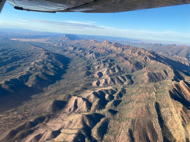
Here's a Geology bit. 800 million years ago an ancient sea bed deposited sediment into a large basin. The ranges are largely composed of folded/faulted sediments from that ancient sea bed. Essentially just the 540 million years old! Due to the inclusion of the sediment they have eroded to form a much lower, rounded set of ranges. Wilpena Pound, has sharp ridge tops as a result of quartzite. This forms the high walls of the Pound as shown in the first photo.
Wilpena Pound is a natural amphitheatre that is 11km long and 8km wide and hemmed in by a series of peaks. 'Wilpena' is said to mean place of bent fingers which might be a reference to the mountains resembling a cupped hand. The traditional owners have no such word in their language and so their name for it is Ikara - meeting place.
The Dreamtime story depicts a slightly different meaning in the creation of the Pound. Personally I can see why it conjures up either imagery.
We opted to stay at Rawnsley Station, about 50km north of Hawker, which was as close to the Wilpena Pound as we could get. From Rawnsley Station we were in the enviable 360 degree position of seeing the Hills of Arkaba, Elder Range, Chace Range, and the Hawker Range in the distance. And most importantly the station was a pet-friendly campground!
Rawnsley Station had originally been predominantly sheep farming but in 1968 Clem Smith's wife, Alison, was instrumental in transitioning into tourism. They opened up a small cabin and offered sheep shearing demonstrations, serving tea and scones in the Woolshed. The Woolshed is now a fine dining restaurant and they have many more cabins including more upmarket eco-villas with pool. The camping area has a number of powered sites and a huge area of unpowered depending on how close you need to be to the amenities blocks!
We scored a result with an unpowered site (powered were all fully booked for days), which was probably the highest up the slope, and therefore had one of the best views of the ranges and the Pound, in my opinion. We figured the slope up and down to the loo put a few folk off. We just smashed our 10,000 steps a day!
A highlight at Rawnsley is the availability of several walks of varying lengths which were all dog friendly....unclear if it was a highlight for Dennis? We managed one of the walks each day for our extended 4 day stay, having originally only booked 2 nights; that's how much we liked it!
Interestingly, both the Heysen Trail and the Mawson Trail pass through Rawnsley on their way to their respective finishes. The former being a 1,200km walking trail from Cape Jervis on the Fleurieu Peninsula (SA) to Parachilna Gorge. The latter is a 900km mountain bike trail from the Adelaide Hills to Blinman and many of the walkers & cyclists camp overnight here before their onward journey north.
And now to the Budget blow-out - flights! We had contingency fund for 'special' items and figured this was one of those. We did end up having a bizarre conversation prior to booking as to what would would happen should we both die in the same craft! Some poor sod would have to deal with a camper van and Dennis stranded in the middle of South Australia! Macabre but the more we thought about it, a very real dilemma. So it was decided, as Von had done rather a lot of flights in helicopters, she would have the fixed wing and I would do the 'helo'. It was only after the event that a number of friends questioned our use of that particular helicopter due to it's safety record!
Suffice to say as I am now typing out the blog, all went well and we both survived our respective flights. Mind you Von did have to swap planes due to a faulty spark plug, and I had a re-start due to a faulty tacho.........
What was particularly good was the ability to have a different photographic experience, and also as it turned out, weather and colour differences. The route was similar although the plane flew a little further and was 10minutes longer as a result. (30mins at $200).The helicopter whilst shorter was more expensive by $70. We both agreed that the experience was definitely worth doing and amazing to see the Pound from the air.
It was hard to leave the incredible sunsets and sunrises and the ever-changing moods of the Ranges but off we headed to Blinman (see map: top right of our route). A few little photo opportunities along the way including the strangely named 'Great Wall of China'. This, unlike anything else in the area, is made up of horizontal slabs of limestone. It is a stand out geological formation for sure.
Blinman is a tiny little hamlet which once had been a copper mining town. It has a Pub and an underground mine tour, and most importantly, a cafe with Cornish pasties! Yes those Cornish miners ended up here too. There was also a fabulous photography exhibition all taken by locals from the Flinders area....put my iPhone shots to shame!
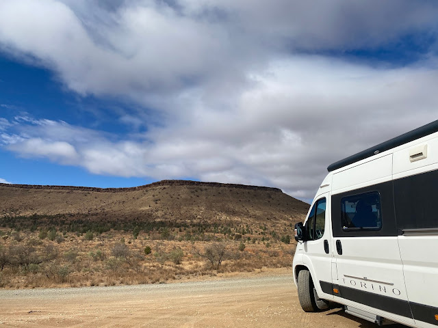
And now for some off-roading in our 2wd/front wheel drive with rain approaching! I know some of our FBookers were a little concerned but I reiterate, we were not alone. It wasn't quite the A1/M6/SH1 but there are quite a few travellers around so we were reasonably confident if we got stuck there were plenty of 4wd's around to tow us out of trouble.
The first 10/15km were quite rough. Rocky and very rutted, so the usual scattering of cushions in the back of the van ensued although these days Dennis stays quite relaxed! We were following the Parachilna Gorge and so crossing a number of bone dry river beds, thankfully only imagining what they must be like when full of flowing water. I'm fairly confident they would close access to 2wd vehicles at that point - hopefully.
We had a stroke of luck though as we came across the 'grader' (like a snow plough but for rocky road surface), so the remainder of the road was reasonably smooth, apart from avoiding feral goats and off-road caravanners who insist on driving at speed.....the caravanners not the goats!
 |
| This section had been graded! |
We reached Parachilna unscathed, and already knowing that the Pub we wanted to visit was closed for renovations (hrmph). Their signature dish is a 'Feral Platter' which is a smorgasbord of emu, kangaroo, and camel. So we will never know what it tasted like....dead to us.
156km later we rolled into our 2 night stay in Quorn, pronounced Corn.
It was always going to be difficult to outshine the Flinders experience and I'm sure there will be more Awe & Wonder along the way, so it was rather fitting that Quorn projected a light show on their Silo showcasing the Flinders.
FABULOUS xx


Comments